


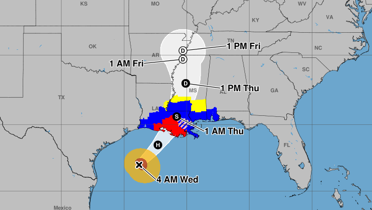
Hurricane Francine strengthened overnight and has become better organized, the National Hurricane Center said, and it's expected to further strengthen over the Gulf of Mexico before landfall in Louisiana later today.
The forecast track and the weather advisories have not changed from Tuesday night, but the storm has become better organized with a more defined eyewall, according to a 4 a.m. forecast discussion from the National Hurricane Center in Miami.
Francine's maximum sustained winds were at 90 mph, and it was moving northeast at about 10 mph. It is expected to pick up speed.
Some additional strengthening is expected throughout the day Wednesday. Francine's sustained maximum winds are expected to reach 100 mph, which is a Category 2 storm. However, it will face some wind shear that's expected to push it more northeast and prevent more strengthening just before landfall.
Little change was reported by NHC forecasters in a 7 a.m. discussion. The storm's wind speeds had not changed and its predicted path remained largely the same.
Hurricane-force winds were extending outward up to 40 mph from the center and tropical-storm force winds were extending outward up to 115 miles.
Francine is forecast to make landfall somewhere near Morgan City, according to a 4 a.m. discussion published by the National Weather Service in Slidell. But once it makes landfall, it is expected to weaken quickly.

Wind speed forecast as of 4 a.m. Wednesday
The storm is expected to make a gradual turn to the north once it makes landfall, bringing the center across eastern Louisiana and Mississippi.
Francine is forecast to bring damaging winds, life-threatening storm surge and 4-8 inches of rainfall across southeastern Louisiana that could lead to flash flooding.

Rainfall forecast as of 4 a.m. Wednesday
The storm surge from Intracoastal City to Port Fourchon and the Vermilion Bay is expected to reach 5-10 feet. From Port Fourchon to the Mouth of the Mississippi River, the storm surge is expected to reach 4-7 feet.
The Baton Rouge and Lafayette areas are under a hurricane warning, and the New Orleans area is under a hurricane watch. All of southeast Louisiana is under a flood watch.
A few tornadoes are possible Wednesday across parts of southeast Louisiana.
Louisiana Gov. Jeff Landry issued a state of emergency ahead of the storm and several parishes have issued mandatory and voluntary evacuations.