


Tropical Storm Francine's track forecast continued to move east Tuesday, and forecasters now expect the storm to make landfall as a hurricane somewhere closer to central or southeast Louisiana.
While it's too soon to know the exact landfall location, the National Hurricane Center's 10 a.m. forecast cone showed another shift to the east, with the storm coming ashore near Morgan City at around 7 p.m. Wednesday.
Hurricane warnings and other alerts were extended east along Louisiana's coast and into Mississippi and Alabama.

A hurricane warning is now in effect for much of the Louisiana coast, from just east of Morgan City to Grand Isle. A tropical storm warning is also in effect from just east of Grand Isle to the Mississippi and Alabama border, including metro New Orleans, Lake Pontchartrain and Lake Maurepas.
A storm surge warning also was extended to cover the area from the mouth of the Mississippi River east to the Mississippi-Alabama border, and a tropical storm watch has been issued for Alabama's entire Gulf Coast.
Here's a comprehensive list of all the evacuation orders that have been issued in Louisiana.
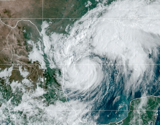
Francine's maximum sustained winds at 10 a.m. Tuesday were still clocking in at 65 mph, according to the Hurricane Center. The storm was slowly moving north-northeast at 8 mph and was anticipated to remain just off the coasts of northeastern Mexico and southern Texas through the day.
The system didn't strengthen much overnight or through the morning despite improved organization, according to Tuesday morning reports from U.S. Air Force Hurricane Hunters.
Forecasters said at 10 a.m. that the storm has about 24-30 hours to strengthen over the Gulf of Mexico's warm waters before it encounters a strong wind shear and dry air near Louisiana's coast, both factors that are expected to hamper further intensification.
RELATED: The 2024 hurricane season is here. Here's what Louisianans can do now to prepare.
Forecasters expect the storm to peak as a Category 2 storm with wind speeds of a little less than 100 mph, but it could weaken slightly before it reaches land.
Francine is expected to bring "life threatening" storm surge to parts of the Louisiana and Texas coasts. Damaging, hurricane-force winds are expected across much of south Louisiana.
The storm is also expected to bring 4-8 inches of rain to the region, with up to 12 inches possible in some areas, depending on where the bands of heavy rain fall. Anticipated rainfall rates could lead to "considerable flash and urban flooding" in Louisiana and Mississippi.
Forecasters with the National Weather Service of New Orleans said impacts to southeast Louisiana will begin Tuesday night and continue to worsen Wednesday. Some parts of the state were already seeing rain from Francine's outer bands early Tuesday morning.
"Preparations should be completed tonight," forecasters said in a post on X shortly after 10:30 a.m.
