


Here’s the expected water heights expected in Louisiana coastal parishes when Tropical Storm Francine's storm surge hammers the state's coastline when it makes landfall somewhere between Lake Charles and Morgan City as a Category 2 hurricane.
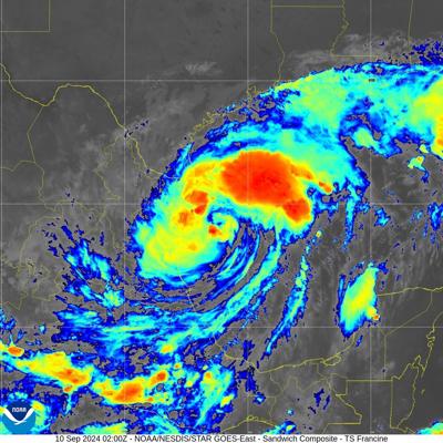
Francine had winds winds of 65 mph at 10 p.m. Monday night and is expected to intensify in the warm Gulf of Mexico. The storm will likely have winds of 100 mph at landfall Wednesday evening.
The list of watch and warning forecast information for coastal parishes was reported by the National Weather Service offices in Slidell and Lake Charles as of 4 p.m. Monday.

This graphic shows the areas where storm surge warnings and watches are in effect on Louisiana's coastline, as of 4 p.m. Monday. (National Hurricane Center)
Southeastern Louisiana:
- Lower Terrebonne Parish, including, Chauvin, Dulac, Montegut, storm surge warning, with the potential for 7-10 feet of water above ground in surge prone areas through Friday morning.
- Upper Terrebonne Parish, no storm surge forecast.
- Lower Lafourche, Parish, including Larose, Golden Meadow, Leeville, storm surge warning with life-threatening storm surge possible, with the potential for 7-10 feet of water in surge prone areas from Tuesday morning until Friday morning.
- Upper Lafourche Parish, no storm surge inundation forecast.
- Coastal Jefferson Parish, including Grand Isle, storm surge warning with the potential for 4-7 feet of water in surge prone areas Tuesday morning until Thursday evening.
- Lower Jefferson Parish, including Lafitte, Barataria, Jean Lafitte, no storm surge inundation forecast.
- Upper Jefferson Parish, including Metairie, Kenner, Harahan, Westwego, Marrero, Gretna, no storm surge inundation forecast.
- Lower Plaquemines Parish, including Port Sulphur, Empire, Venice, storm surge warning with the potential for 4-7 feet of water above ground in surge prone areas through Friday morning.
- Central Plaquemines Parish, including Braithwaite, Alliance, no storm surge inundation forecast.
- Upper Plaquemines Parish, including Belle Chasse, no storm surge inundation forecast.
- Lower St. Bernard Parish, including Yscloskey, Delacroix, Shell Beach, storm surge watch, with the potential for 2-4 feet of water above ground in surge prone areas through Friday morning.
- Upper St. Bernard Parish, including Chalmette, Meraux, Violet, no watch, but localized storm surge is possible, with the potential for 1-3 feet of water above ground in surge prone areas through Friday morning.
- Eastern New Orleans, storm surge watch, including Lake Catherine, with the potential for 2-4 feet of water above ground in surge prone areas through Friday morning.
- Western New Orleans, including the city and Lakefront Airport, no watch but localized storm surge is possible, with the potential for 1-3 feet of water above ground in surge prone through Friday morning.
- St. Charles Parish, including Norco, Des Allemands, Boutte, storm surge watch, with the potential for 2-4 feet of water above ground in surge prone areas from Tuesday morning until Friday morning.
- St. John the Baptist Parish, including LaPlace, Reserve, storm surge watch, with the potential for 2-4 feet of water above ground in surge prone areas from Tuesday morning until early Friday morning.
- St. James Parish, including Lutcher, Gramercy, no storm surge inundation forecast.
- Assumption Parish, including Pierre Part, Napoleonville, Labadieville, no storm surge inundation forecast.
- Eastern Ascension Parish, no storm surge inundation forecast.
- Western Ascension Parish, including Gonzales, Prairieville, Geismar, Donaldsonville, no watch in effect, but localized storm surge possible with up to 2 feet of water above ground in surge prone areas through Friday morning.
- Iberville Parish, no storm surge inundation forecast.
- East Baton Rouge Parish, including Baton Rouge, no watch in effect, but the potential for up to 2 feet of water above ground in surge prone areas through Friday morning.
- West Baton Rouge Parish, including Port Allen, Brusly, no storm surge inundation forecast.
- Pointe Coupee, no storm surge inundation forecast.
- West Feliciana, no storm surge inundation forecast.
- East Feliciana, no storm surge inundation forecast.
- Southern Livingston Parish, including Springfield, Killian, Whitehall, French Settlement, storm surge watch in effect, with the potential for 2-4 feet of water above ground in surge prone areas through Friday morning.
- Northern Livingston Parish, no storm surge inundation forecast.
- St. Helena Parish, no storm surge inundation forecast.
- Lower Tangipahoa Parish, including Ponchatoula, Akers, storm surge watch in effect with the potential for 2-4 feet of water above ground in surge prone areas -: Tuesday morning until early Friday morning
- Central Tangipahoa, no storm surge inundation forecast
- Northern Tangipahoa, no storm surge inundation forecast
- Southeast St. Tammany Parish, storm surge watch in effect, Slidell, Life-threatening storm surge possible- Peak Storm Surge Inundation: The potential for 2-4 feet above ground in surge prone areas - Window of concern: through Friday morning
- Southwestern St. Tammany Parish, storm surge watch in effect, Mandeville, Madisonville, Life-threatening storm surge possible- Peak Storm Surge Inundation: The potential for 2-4 feet above ground in surge prone areas - Window of concern: through Friday morning.
- Northern St. Tammany, Covington, Folsom, Bush, no storm surge inundation forecast.

This graphic shows the estimated height of storm surge expected along the Gulf Coast from Hurricane Francine, as of 4 p.m. Monday. (National Hurricane Center)
South Central and Southwest Louisiana:
- West Cameron Parish, including Johnson Bayou, Holly Beach, Hackberry, storm surge warning in effect with the potential for 3-5 feet of water above ground somewhere in surge prone beginning early Tuesday morning.
- East Cameron Parish, storm surge warning in effect with the potential for 7-10 feet of water above ground in surge prone areas beginning Tuesday morning.
- Lower Vermilion Parish, including Abbeville, Intracoastal City, Forked Island, storm surge warning in effect with the potential for 7-10 feet above ground in surge prone areas beginning Tuesday morning
- Lower Iberia Parish, including Avery Island, storm surge warning in effect, with the potential for 7-10 feet of water above ground in surge prone areas beginning Tuesday morning
- Lower St. Mary Parish, including Burns Point, Cypremort Point, storm surge warning in effect, with the potential for 7-10 feet of water above ground in surge prone areas beginning Tuesday morning
- Upper St. Mary Parish, including Morgan City, Centerville, Patterson, Franklin, Berwick, Bayou Vista, storm surge warning in effect, with the potential for 4-6 feet of water above ground in surge prone areas beginning Monday evening.
- Lower St. Martin Parish, no surge watch, but the potential for 2-4 feet of water above ground in surge prone areas beginning Monday evening.
- Upper Iberia Parish, including New Iberia, Jeanerette, no surge watch, but the potential for 2-4 feet of water above ground in surge prone areas beginning Monday evening.
- Upper Vermilion Parish, including Gueydan, Meaux, Kaplan, Maurice, no surge watch in effect, but the potential for 1-3 feet of water above ground in surge prone areas Tuesday afternoon until Thursday evening.
- Southern Acadia Parish, no storm surge inundation forecast.
- Southern Jefferson Davis Parish, including Lake Arthur, no surge watch in effect, but the potential for up to 2 feet of water above ground somewhere within surge prone areas from Tuesday afternoon until Thursday evening.
- Southern Calcasieu Parish, including Lake Charles, Carlyss, Bell City, Hayes, Iowa, no surge watch in effect, but the potential for 1-3 feet of water above ground in surge prone areas beginning early Tuesday morning.
- Northern Calcasieu Parish, no surge watch in effect, but the potential for 1-3 feet of water above ground in surge prone areas Tuesday afternoon until Thursday evening.
- Northern Jefferson Davis Parish, including Hathaway, Jennings, Topsy, Fenton, Welsh, Elton, no surge watch in effect, but the potential for up to 2 feet of water above ground in surge prone areas from Tuesday afternoon until Thursday morning.
- Northern Acadia Parish, including Crowley, Rayne, Branch, Church Point, Iota, no surge watch in effect, but the potential for up to 2 feet of water above ground in surge prone areas from Tuesday afternoon until Thursday afternoon.
- Lafayette Parish, including Lafayette, Carencro, Youngsville, no storm surge inundation forecast.
- Upper St. Martin Parish, including St. Martinville, Breaux Bridge, Butte LaRose, no surge watch in effect, but the potential for 1-3 feet of water above ground in surge prone areas beginning early Tuesday morning.
- St. Landry Parish, including Opelousas, Eunice, Krotz Springs, no surge watch in effect, but the potential for 1-3 feet of water above ground in surge prone areas beginning Tuesday morning.
- Evangeline Parish, no storm surge inundation forecast.
- Allen Parish, no storm surge inundation forecast.
- Beauregard Parish, no storm surge inundation forecast.
- Southern Newton Parish, no storm surge inundation forecast.
- Southern Jasper Parish, no storm surge inundation forecast.