


Heavy rain and strong winds could be felt as Hurricane Francine began blowing through the capital area Wednesday evening.
Impacts from the hurricane could already be seen in Baton Rouge early Wednesday afternoon, and will continue through Wednesday night. The worst conditions are expected between 7 p.m. Wednesday and 2 a.m. Thursday, according to National Weather Service meteorologist Danielle Manning.
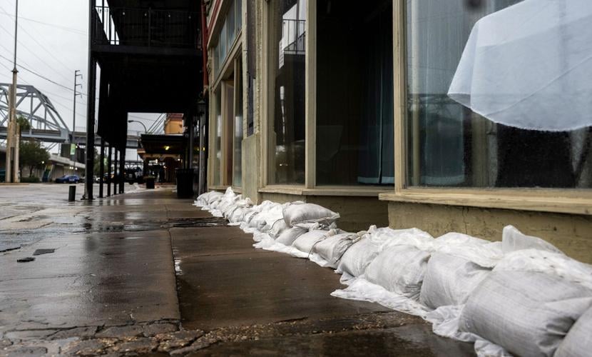
The NWS forecasts 4 to 8 inches of rain in the region, with higher amounts in certain areas and possible flash flooding. Wind gusts over 60 mph are also expected.
The biggest threat to residents are flash flooding and fallen trees, Manning said, noting the ground is more saturated due to rainfall last week.
Manning said conditions should improve after midnight.
Baton Rouge emergency responders have spent the past couple days preparing for the worst. Peak winds of 90 mph have already been reported, and some parts of Louisiana could see 12 inches of rain.
"It'll depend on the timeline and how that's going to affect us," said Clay Reeves, director of the East Baton Rouge Parish Mayor's Office of Homeland Security & Emergency Preparedness. "The message we're putting out now at this stage, is expect high water and expect winds that are being forecast at the worst."
East Baton Rouge Mayor-President Sharon Weston Broome said she spoke to Louisiana Gov. Jeff Landry on Wednesday morning and will continue to stay in contact with state officials over the coming days.
Broome is also in contact with U.S. Rep. Garret Graves, she said, as well as Entergy and other mayors in East Baton Rouge Parish, so resources can be efficiently coordinated.
"We've laid a foundation. We've prepared," Broome said. "I want to make sure that we carefully expedite our response after the impact takes place."
Debris cleanup services in St. George will be provided by the city-parish, Baton Rouge officials said, as the new city has only recently begun to form its government.
Tornado watches and flash flood warnings issued
A tornado watch has been called for 19 Louisiana parishes, including six in the Baton Rouge area.
The watch is in effect until 11 p.m. Wednesday. A watch means severe thunderstorms and tornadoes are possible in and near the watch area.
The following Baton Rouge-area parishes are in the watch area: Ascension, Assumption, Iberville, Livingston, St. James and Tangipahoa.
Other Louisiana parishes under the watch are Iberia, Jefferson, Lafourche, Orleans, Plaquemines, St. Bernard, St. Charles, St. John the Baptist, St. Martin, St. Mary, St. Tammany, Terrebonne and Washington.
A flash flood warning is also in effect in the Donaldsonville, Gramercy and Lutcher area until 12:45 a.m. Thursday. The NWS urges affected residents to move to higher ground immediately and avoid walking or driving through flood waters.
Local curfews
As of late Wednesday afternoon, the Feliciana parishes appeared to be on the western outskirts of the cone. West Feliciana officials tracked Francine from the parish’s St. Francisville command center and kept watch as the storm ambled across the Gulf.
“We’re monitoring the storm as everyone else is. We feel like we’ve got a good plan in place and are prepared for anything that’s likely to come about,” Sheriff Brian Spillman said.
On Tuesday, Clinton Mayor Mark Kemp declared a curfew for the town that begins at 7 p.m. Wednesday. Only essential and emergency personnel will be allowed on the streets overnight until 6 a.m. Thursday.
Elsewhere in East Feliciana Parish, extra sheriff’s deputies will be on duty Wednesday night, and recovery crews are in place to help clear the roads once the storm passes.
“The biggest thing is we need to encourage everybody to take shelter and stay off the roads when it deteriorates,” Sheriff Jeff Travis said. “It’s kind of difficult for us to get out there when the weather is dangerous, so we need everyone to adhere to the warnings and stay off the roads as much as possible. And hopefully we dodge a bullet here.”
Officials in Livingston Parish announced a curfew starting Wednesday from dusk until dawn. The City of Gonzales implemented a similar curfew.
Iberville Parish has a curfew in effect starting 6 p.m. Wednesday until 6 a.m. Thursday. Zachary has a city-wide curfew from 7:30 p.m. Wednesday until 7 a.m. Thursday.
St. James Parish officials said Wednesday morning that a curfew is not planned, but a shelter in place order was put in effect beginning at 1 p.m. Wednesday.
Shelters open
Several parishes in the Baton Rouge region opened shelters of "last resort" for Hurricane Francine.
The following shelters are open during the storm:
Ascension Parish
- Lamar-Dixon Expo Center in the gym, 9039 S. St. Landry Ave., Gonzales. Opened at 12:30 p.m. Wednesday.
Assumption Parish
- Assumption Parish Community Center, 4910 Hwy. 308, Napoleonville. Opened at 9 a.m. Wednesday.
Iberville Parish
- White Castle Community Center, 32725 Bowie St., White Castle, LA 70788. Opened at 10 a.m. Wednesday.
- St. Gabriel Community Center, 1400 Gordon Simon Leblanc Drive, St. Gabriel, LA 70776. Opened at 10 a.m. Wednesday.
St. Helena Parish
- 5th Ward Multiple Purpose Center, 31676 Hwy 16. Opened at 10 a.m. Wednesday.
St. James Parish
- West Bank Reception Hall, 2455 Hwy. 18 Vacherie. Opened at 7 a.m. Wednesday.
- Lutcher Senior Center, 2631 Louisiana Ave., Lutcher. Opened at 7 a.m. Wednesday.
Tangipahoa Parish
- Restoration Church, 22494 US 190, Robert. Opened Tuesday.
- Amite Community Center, 101 W. Chestnut St. in Amite. Opened Tuesday.
- Brown’s Chapel, 70427 Martin Luther King Drive, Village of Tangipahoa. Opened Tuesday.
West Baton Rouge Parish
- Port Allen Community Center, 749 N Jefferson Ave., Port Allen. Opened at 11:30 a.m. Wednesday and will stay open for 24 hours.
Preparing waterways
East Baton Rouge Director of Transportation Fred Raiford said plenty of effort has gone into cleaning drainage pipes in the Comite and Amite rivers, which he believes will result in less flooding from Francine than in previous hurricanes and storms.
"When I go out and look at these waterways when it rains, the water is really moving compared like it used to a few years ago," Raiford said.
The city-parish has been able to allocate manpower to clearing area waterways in recent years because of American Rescue Plan Act funding, Raiford said.
Raiford will be paying particularly close attention to drainage at Bayou Manchac, he said, as it drains some of the largest bayous in the parish.
Broome said she believes most parish residents were already well-prepared by Wednesday afternoon, but still reminded people to stay calm and call 311 if they need any assistance.
For residents living close to waterways, Raiford said residents should not panic and that crews have done everything possible to prep parish drains for incoming rain.
With Francine just hours from arrival in Baton Rouge, Reeves said the most important thing is for residents to understand what the risks are.
"People need to know what the threat is. If you live by a waterway, that's probably your No. 1 threat," he said. "You may have someone in your household that relies on power, then that's your No. 1 threat."
"Stay informed. Have a plan in place already and don't act haphazardly," Reeves said. "Call 311 for help … and 911 for (threats to) life safety."
Power outages
Power and communication outages are expected throughout the state. Baton Rouge officials are prepared to open up a post-storm shelter if those outages puts lives at risk, Reeves said.
"As soon as it's safe for us to go out, we'll go out and see what the damage is, do the assessment and start responding to 911 or any types of emergency calls," Reeves said.
To check outages in your area, click here.
Road closures
As the storm rolled in, St. James Parish President Pete Dufresne said operations and emergency crews were ready to respond.
“We have our operations crews, they have separate crews on each side of the river that’s sheltering in place with their equipment, ready to be able to cut and push trees or debris or anything off the roadway,” Dufresne said.
“Everybody is on standby and ready to respond to any incidences that we may need to, but hopefully, hopefully it stays pretty quiet.”
Law enforcement agencies around the Baton Rouge area have started closing parts of some roadways Wednesday afternoon as Hurricane Francine nears, bringing down trees and power lines.
Iberville Parish officials said that La. 1 and La. 405, which is River Road, are closed due to downed power lines just south of their parish in Ascension. The highways are the two main routes between western Iberville and Ascension.
La. 1 north of Donaldsonville is closed at La. 405, according to Ascension Parish Sheriff Bobby Webre.
La. 405 is closed a few miles south of the Iberville Parish line, Iberville officials said. This area is in Ascension upriver of Donaldsonville.
The Sheriff's Office is also working to remove a tree across Bayou Narcisse Road at Cleo Road in Gonzales.
The 4700 block of La. 308 in Assumption Parish was closed due to a tree falling across the highway along Bayou Lafourche. Parish officials said the tree will not be cleared until winds die down. A gust of 61 mph was recorded in Napoleonville around 6 p.m. Wednesday.
Denham Springs police said they are removing a fallen tree on River Road.
Office and school closures
City-parish offices will remain closed Thursday, Broome said in a news release. Curbside garbage, recycling and out-of-cart services will resume Thursday with a delayed start. Residents are encouraged not to place their carts and out-of-cart items curbside until Thursday morning.
The North Landfill will open at 9 a.m. Thursday and close at 5 p.m. Starwood Court Collection Facility will remain closed Thursday, Broome said.
Ascension Parish announced its government offices will reopen at 12:30 p.m. Thursday and resume regular operating hours on Monday.
The Ascension Parish Health Units will reopen at 11 a.m. Thursday.
Most schools in the Baton Rouge area announced closures Wednesday and Thursday, with plans to reopen Friday.
On Wednesday, LSU canceled remote classes for Thursday and issued a shelter in place for students on campus until 1 p.m. Thursday.
For a full list of school closures, click here.
Don't miss a storm update this hurricane season. Sign up for breaking newsletters here. Follow our Hurricane Center Facebook page here.


