

Hurricane forecasters said Thursday that a broad area of low pressure that is expected to develop in the northwestern Caribbean Sea early next week could move into southern Gulf of Mexico.
Once it forms, the low-pressure system is expected to slowly develop and could become a tropical depression while shifting from the Caribbean to the Gulf, according to the National Hurricane Center in Miami.
As of Thursday morning, forecasters said there was a 40% chance the disturbance would form into a tropical depression or storm within the next week.
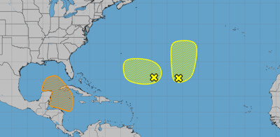
Disturbance southeast of Bermuda
Located about 750 miles southeast of Bermuda, hurricane forecasters spotted a new area of low pressure in the Atlantic.
While the new system is dumping disorganized showers and thunderstorms over the area, the likelihood of it developing in the next two days is low, meaning 20%. However, some development is possible early next week as the disturbance meanders over the central or western subtropical Atlantic, hurricane forecasters said.
Remnants of Tropical Storm Gordon
Meanwhile, remnants of Gordon continue to produce the central subtropical Atlantic with disorganized showers and thunderstorms.
Forecasters said some redevelopment of the system is possible in the next few days as it moves northward.
The remnants have a 20% chance of forming in the next two days, hurricane forecasters said, and a 30% chance of development in the next week.
Don't miss a storm update this hurricane season. Sign up for hurricane update newsletters. Follow our Hurricane Center Facebook page.